 |
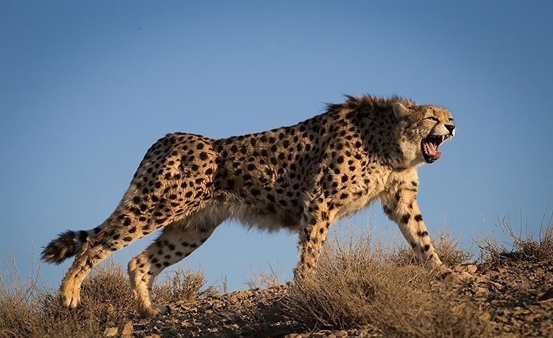
| Asiatic cheetah |
For wildlife conservationists working to save endangered species, the greatest threat is often assumed to be poachers or habitat destruction. For a group of Iranian researchers, however, their conservation work led them behind prison walls. In January 2018, eight Iranian conservationists were arrested on allegations of espionage after authorities claimed that wildlife camera traps used to monitor endangered wildlife were instead being used to gather intelligence, including information about Iran's missile program. Among those detained was Kavous Seyed-Emami, director of the now-defunct Persian Wildlife Heritage Foundation (PWHF). Just weeks later, he died in custody, with Iranian authorities ruling his death a suicide—a conclusion his family has consistently challenged. Also among those arrested were renowned conservationists and husband-and-wife team Houman Jowkar and Sepideh Kashani. Widely respected for their work to protect the critically endangered Asiatic cheetah—of which fewer than 30 individuals are believed to remain in the wild—the couple devoted years to studying and safeguarding one of the world's rarest big cats. After serving years in Tehran's notorious Evin Prison, they were pardoned and released in April 2024. Their freedom, however, was short-lived. On July 1, 2026, Jowkar and Kashani were arrested once again, this time alongside Kashani's sister, Sima. According to their attorney, Hojjat Kermani, security agents raided the couple's home, confiscated electronic devices, and took all three into custody. Iranian authorities have not publicly disclosed the reasons for Sima Kashani's arrest.
 |
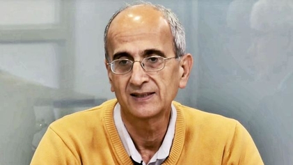
| Houman Jowkar (back) and his wife Sepideh Kashani. |
The latest arrests have sparked renewed concern within the international conservation community. Kylie Moore-Gilbert, a British-Australian academic who was imprisoned in Iran on separate espionage charges in 2018 and later shared a prison cell with Sepideh Kashani, wrote on Instagram that the couple are "not political activists." She also noted that Sima Kashani has multiple sclerosis and requires essential medical treatment, while the sisters' father is reportedly in poor health. The Wildlife Conservation Society (WCS) has likewise called on Iranian authorities to "clarify the legal status and current whereabouts of Ms. Kashani, Mr. Jowkar, and Sima Kashani immediately." As uncertainty surrounding their detention continues, conservation organizations and supporters around the world are once again calling for transparency and due process for three people whose life's work has been dedicated to protecting wildlife.
 |
| Former PWHF director Kavous Seyed-Emami who died while in custody. |
The challenges facing wildlife conservation in Iran extend far beyond habitat loss and other human-driven pressures. Years of geopolitical instability, armed conflict, and restrictions on scientific research have created an increasingly difficult environment for conservationists working to protect the country's unique biodiversity. The arrests and imprisonment of wildlife researchers on espionage charges have only deepened these challenges, disrupting critical conservation efforts and casting a shadow over scientific work. The case of the eight conservationists arrested in 2018 remains one of the most troubling examples. After spending six years behind bars, Houman Jowkar and his wife, Sepideh Kashani, were pardoned and released in 2024, only to be arrested again this year. Their renewed detention has reignited concerns within the international conservation community about the future of wildlife research in Iran. The consequences extend beyond the individuals involved. Jowkar and Kashani have dedicated much of their careers to protecting the critically endangered Asiatic cheetah, a subspecies now believed to number fewer than 30 individuals in the wild. Every disruption to research, monitoring, and conservation efforts narrows the already fragile path to recovery for one of the world's rarest big cats. Iran has already witnessed the disappearance of two of its iconic predators—the Asiatic lion and the Caspian tiger. Allowing the Asiatic cheetah to follow the same path would represent another irreversible loss, not only for Iran's natural heritage but for global biodiversity. At a time when every remaining cheetah counts, supporting the scientists working to protect them is more important than ever.
The future of the Asiatic cheetah in Iran is becoming increasingly uncertain as repeated arrests of experienced conservationists continue to disrupt vital research and recovery efforts. While encouraging developments in cheetah conservation elsewhere in the region, including Saudi Arabia, offer reasons for optimism, the long-term survival of this iconic subspecies will require sustained commitment and international cooperation. As the last wild refuge of the Asiatic cheetah, Iran remains central to that mission. The renewed detention of researchers such as Houman Jowkar and Sepideh Kashani has raised fresh concerns about the future of conservation in the country. Their years of expertise, fieldwork, and dedication cannot be easily replaced, particularly for a species believed to number fewer than 30 individuals in the wild. Many conservationists and human rights advocates have called for greater international engagement to help ensure that wildlife researchers can carry out their work without fear of detention. International conservation organizations, including WWF, together with governments and other global partners, could play an important role by encouraging dialogue, supporting scientific collaboration, and advocating for due process and the well-being of detained conservationists. Protecting the Asiatic cheetah ultimately means protecting not only the species itself, but also the people whose knowledge and commitment are essential to its survival.


.jpg/1920px-Myanmar_Illicit_Endangered_Wildlife_Market_04_(cropped).jpg?utm_source=en.wikipedia.org&utm_campaign=parser&utm_content=thumbnail)

_(32575640450).jpg)